The aim of this action is to use the information collected in action B1, the ones acquired in action B2 and the results of the elaborations of action B.3 into a Forest Information System (FIS) to support their implementation in real local forest management activities. A FIS is generally considered as a working tool. It is designed to help forest manager to perform certain recurrent tasks. After consulting the three local partner we decided to proceed as indicated in the project proposal using a standard GIS software already available at forest managers offices and loaded with all the layers obtained in the previous action of the project. The software chosen was QGIS an open source GIS that as the same potentiality of proprietary ones but allow us to install the FIS on all the computers we want without license problems. In fact, some local managers have offices located far from each other (UCVV for example) and this solution allow them to use the FIS everywhere. The first beta version of the FIS has been installed in June 2018 in the offices of the UCVV local manager of the demonstration site of Rincine, in schedule with the milestone “FIS installation” foreseen in Action B4. During the summer 2018 we had a testing period during which the UNIFI team fixed all the problems occurred in the FIS and collected the feedbacks from the users. The team of the UCVV try to use the different layers for their forest management activities giving suggestions on how to improve the system in order to make it more efficient and easy to use. This intense exchange of opinions also generated many ideas on how expand the capabilities of the FIS, this part will be better investigated in Action B5 concerning the upscaling of the project. To give a better explanation about the operation of the FIS we attach this table with a list of the layers loaded in the GIS software for the demonstration site of Rincine also indicating their provenience.
| name of the layer | related action | raw data |
| border of the state forest | B1 | existing data |
| border of the national park | B1 | existing data |
| roads | B1 | existing data |
| hydrography | B1 | existing data |
| regional technical map (CTR) | B1 | existing data |
| map of the old management plan | B1 | existing data |
| border of the demonstration site | B1 | created in action B1 |
| field data | B2 | acquired in action B2 |
| orthophoto RGB | B2 | acquired in action B2 |
| orthophoto NIR | B2 | acquired in action B2 |
| digital terrain model (DTM) | B4 | elaborated from LIDAR data |
| slope map | B4 | elaborated from LIDAR data |
| aspect map | B4 | elaborated from LIDAR data |
| map of the European Forest Types (EFTs) | B3 | elaborated from orthophotos/field data |
| map of “defoliation” indicator | B3 | elaborated from orthophotos/field data |
| map of “forest damage” indicator | B3 | elaborated from orthophotos/field data |
| map of “introduced tree species” indicator | B3 | elaborated from orthophotos/field data |
| map of “tree species composition” indicator | B3 | elaborated from orthophotos/field data |
| map of “growing stock” indicator | B3 | elaborated from LiDAR/field data |
| map of “above ground biomass” indicator | B3 | elaborated from LiDAR/field data |
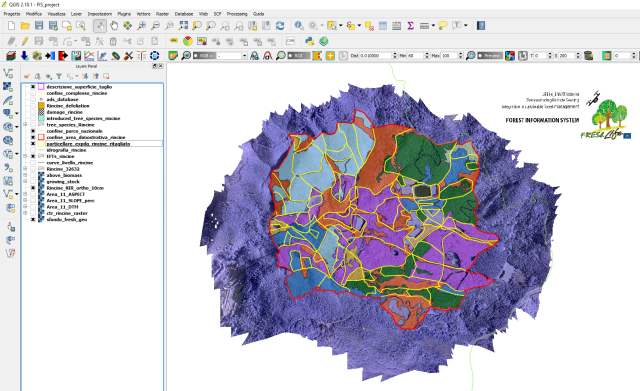
Screenshot from the FIS of Rincine

Technician of the UCVV while using the FIS in their offices
Concluded the testing period the system is now ready and the second phase has begun with the installation in the offices of the Municipality of Carparola and Molise Region. UNITUS and UNIMOL are installing the FIS in the offices of their related local partners and train the users on the potentiality of the system.